Stormwater Master Plan

Photo of street flooded with water

Water-Drop.jpg

City of Miami - 2024 Map of SWMP Priority Projects Citywide

The map below depicts the list of 25 priority projects identified under the Storm Water Master Plan Citywide (flood prevention projects).
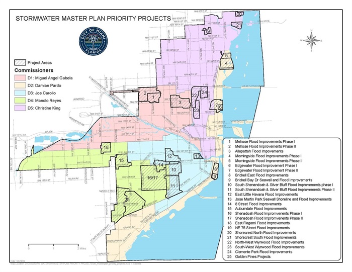
City of Miami - 2024 Map of Stromwater Master Plan Priority Projects Citywide

Stormwater Master Plan (SWMP) Workshop
MFB Citizens’ Oversight Board and Climate Resilience Committee (CRC) on Wednesday 9/7/22

The City of Miami Office of Capital Improvements (OCI) hosted a Stormwater Master Plan (SWMP) workshop to present an update of the SWMP plan to the MFB Citizens’ Oversight Board and Climate Resilience Committee (CRC), including the public. 
The workshop took place at City Hall in the Staff Conference Room on Wednesday 9/7/22.   The meeting was virtual and in-person.  The main presenters at the workshop were: CDM Smith (project consultants), the Office of Capital Improvements (OCI) and Resilience and Public Works (RPW). 

Click here to download the workshop presentation(PDF, 2MB)

The Office of Capital Improvements is excited to announce...

that the City of Miami has earned an improved Community Rating System (CRS) rating from the National Flood Insurance Program (NFIP). The new Class 6 rating will provide City property owners and renters up to 20 percent discount on flood insurance premiums beginning Oct. 1, 2022.

Click here to download the CRS Rating letter received by the City of Miami from FEMA(PDF, 218KB)

The City’s floodplain management efforts include:
  1. Updating the Citywide Stormwater Master Plan
  2. Improving flood risk mapping and floodplain development standards that address local flood risk and conditions
  3. Drainage system maintenance, including checking hot spot areas before and after significant storms to ensure conveyances are clear and perform as designed
  4. Expansion of the Program for Public Information membership across municipalities in the county and development of activities, such as the online Flood Map Service, Tidal Valve installations, to name a few.

The City continues to encourage property owners to know their risk for flooding and to contact their insurance agent to purchase flood insurance and understand what is covered. For more information, call the National Flood Insurance Program Help Center at 1-800-427-4661 or visit the FEMA Office of the Flood Insurance Advocate (OFIA) at www.fema.gov/flood-insurance/advocate.”

Overview

The City of Miami completed the 2021 update to the Stormwater Master Plan (SWMP), a comprehensive assessment of the city’s roads, drainage infrastructure, and water management features to identify improvements needed to address capacity and flooding issues. The final report prioritizes recommendations to be included within the city’s Capital Improvement Plan, taking into consideration changing climactic patterns, sea level rise (SLR), and the desire to strengthen the resiliency of Miami.

The City of Miami presented a series of virtual community meetings in April and May of 2021 to update residents on the City’s 2021 Comprehensive Citywide Stormwater Master Plan Report.  All meetings were designed to provide citywide information about the SWMP, and were divided into four regions:  Coastal North, Coastal Central, Coastal South and Inland West.

Stormwater System is a system that exists throughout our communities to reduce runoff of rainwater away from our roads, prevent flooding of roadways, buildings and parking lots and improves water quality.

The stormwater drainage system includes pipes, ditches, curbs, gutters, culverts and the purpose of all these is to collect stormwater overflow and discharge it away from our roads, homes and businesses.

A Stormwater Master Plan is a comprehensive stormwater management plan which addresses stormwater runoff and residue from rain/or hurricane events. The goal of stormwater master plan is to help the City understand its current state of the stormwater system and recommend environmentally comprehensive and resilient storm drain designs to address current problems and/or areas where future challenges may occur.

The plan will further recommend design standards for new development/re-development, transportation, water quality, floodplain mitigation, inadequate storm sewer and culvert system, channels and swales.

The results of the plan will be invaluable to the City as it will be used as a guide to address flooding and stormwater management requirements, establish requirement on climate adaptation and recommend projects for subsequent Tranches of the Miami Forever Bond.

  • Protecting Biscayne Bay
  • Sea Level Rise
  • Low/Flat Terrain & High Groundwater Table 
  • Water Resistant/Flood Prone Urban Areas
  • Saltwater Intrusion 
  • Higher Tides and Backflow 
  • Manatee Access to Stormwater System

The Plan Update evaluated higher sea levels using the adapted projections of the Southeast Florida Regional Climate Change Compact and reduce ability for the ground to absorb rain storms as ground water levels rise with rising seas.

Phase 1:   Data Collection

This phase includes available data source reviews, data transfers from the City of the information related to the stormwater system, the design development and data extraction and coding of a new geographic information system (GIS), creation of the City new stormwater atlas map, repetitive loss and level of service analyses, a flood stage gauge network initial evaluation, field survey of the existing seawalls and channel cross section for canals.

Phase 2: Flood Modeling

This phase includes the engineering and analysis to create and run the stormwater models which includes digital terrain elevation model surface (DEM), establishment of watersheds and subcatchments, identification of the PSMS extents and coding of the PSMS data, soils capacities, aquifer transmissivity, groundwater levels, boundary conditions, gate operations and tides interaction, and pervious and impervious coverages. The task

includes model runs for three design storms and two sea level rise conditions, water quality analysis, flood plain maps for the scenarios run, prioritized and phased proposed capital improvements to mitigate flooding with cost estimation and update stormwater design standards criteria.

Phase 3: Infrastructure Recommendations 

This phase includes system resiliency analyses for extreme events, and inundation mapping under future SLR scenarios, an extreme rainfall model run analysis, and a summary of resilient CIP features.

Phase 4: Policy Guidance Design Standards 

This phase develops a twenty-year CIP for a chosen level of service, project prioritization based on needs, regulatory compliance coordination, transfer and training of City Staff on the use of the models, and presentations of the results and recommendations to stakeholders.

Phase 5: Tools & Training

This phase incudes training the city staff on using the new and updated models.  

Task A – Data Gathering and Analysis (Complete)

Task B -  Modeling (Complete)

  • All models in CIP Alternatives Phase
  • Exfiltration systems CIP complete
  • Drainage wells CIP Complete
  • Storm sewers CIP in progress
  • PSs and Injection wells pending
  • Assistance with local severe flooding immediate project guidance continuing

Task C – SLR Seawall Height Analysis (Complete)

  • SLR CIP Analysis Pending CIP Model Run

Task D – Report and CIP (Complete)

  • Data Gap TM Complete
  • Stage Gage TM Complete
  • Model Development TM Complete
  • Model Application TM In progress
  • GIS Development TM in Progress

Click here(PDF, 259KB) to view the Stormwater Master Plan Update Event Invitation!

List of 4 SWMP Virtual Community Meetings In April and May 2021:


1.SWMP  Coastal South  Virtual Meeting – Monday, April 26, 2021 at 6:00pm

Includes the following neighborhoods: Virginia Key, Coconut Grove and Dinner Key Marina (District 2): 

Click here to view SWMP Costal South Meeting recording

2.SWMP Coastal North Virtual Meeting  –  Thursday, April 29th, 2021 at 6:00pm

Includes the following neighborhoods: Edgewater, Venetian Isles , Eastside, Little Haiti, Overtown, Model City and Wynwood. (District 5 and District 2)

Click here to view the SWMP Costal North Meeting recording

3.SWMP Inland West Virtual Meeting – Tuesday, May 11, 2021 at 6:00pm

In-Person/Virtual Meeting (Bilingual and Hybrid Format) – In-person Venue TBD

Includes the following  neighborhoods: Allapattah, Little Havana, North Flagami (Grapeland), South Flagami and Coral Way. (District 1, District 3 and District 4)

Back-to-back meetings were held, with the first meeting in English, followed by a second meeting in Spanish.

4.SWMP Coastal Central Virtual Meeting – Wednesday, May 12, 2021 at 6:00pm

Includes the following neighborhoods: Brickell, Downtown (Biscayne Blvd), Riverside (Jose Marti Park), The Roads and Coral Way. (District 2 and District 3)

Click here to view the SWMP Costal Central Meeting recording

XXX